Shallow Aquifer Groundwater Facies At Multiple Landuse Sites In Manglayang Volcanic Area, Jatinangor And Surroundings, Indonesia
DOI:
https://doi.org/10.25299/jgeet.2021.6.2.3315Keywords:
Volcanic aquifer, Manglayang Mountain, Landuse, Groundwater FaciesAbstract
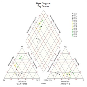
Manglayang Mountain is generally composed by old and young volcanic materials. Older rocks are located around the northern part of mountain peak, in medial and distal parts. In the southern and southeastern parts composed by relatively young volcanic rocks starting from the proximal, medial to distal. These geologic conditions produce diverse aquifer systems. These differences in land use environments contribute to water quality conditions in local shallow aquifers. The research is therefore carried out in order to the effect of difference in land use environments on groundwater facies by dividing the area based on each land use. Land use in the research area is dominated by allotment of agricultural land, settlement, and industry. The study was conducted from the medial area to distal to the southern part of Manglayang Mountain, administratively including Sukasari, Jatinangor, and Rancaekek districts. To observe the groundwater conditions in the aquifer from the study area, physical and chemical parameters were tested. Chemical parameter test results were plotted using piper diagrams and Durov diagrams as a method that can illustrate the condition of groundwater facies. Physical characteristics of groundwater may reflect groundwater interactions with rocks. Measurable TDS concentrations of 48 - 299 mg / L and measured EC 100 - 1020 μmhos / cm, show different interaction conditions between groundwater with rocks or have received different material subsidies. Similarly, the occurrence of temperatures that vary considerably between air and water indicates the distance of groundwater sources with various water bodies. The groundwater facies that developed in the research area are generally dominated by Ca, HCO3 in the agricultural land use area, Mg, HCO3 in the settlement area, and in some Cl-facing evolving places in the industrial land use zones. In addition, there are also indications of mixing of anions and cations in groundwater samples in all three land use areas. This indicates that there has been a change in groundwater characteristics in some areas of land use utilization in the research area
Downloads
References
APHA, 2012. Standard Methods for Examination Water and Waste Water. 21th edition Washington DC, USA
Badan Koordinasi Survey Dan Pemetaan Nasional, 2001. Peta Rupa Bumi Digital Indonesia Lembar Cicalengka 2001.
Bappeda Kabupaten Sumedang, 2009. Studi Kelayakan Kawasan Jatinangor sebagai Kawasan Perkotaan.
Bermana, I. (2006). Klasifikasi geomorfologi untuk pemetaan geologi yang telah dibakukan. Bulletin of Scientific Contribution, 2(4).
Hadian dkk, 2013 Penentuan Zona Resapan Dan Umur Air Pada Endapan Vulkanik Di Kawasan Jatinangor Dengan Mengunakan Metoda IsotopStabil. Buletin geologi Tata Lingkungan. ISSN 1410-1696 Vol. 23 No. 3 Desember 2013
Lloyd, J. W., & Heathcote, J. A. (1988). Natural inorganic hydrochemistry in relation to groundwater: an introduction. Clarendon Press.
Mandel, S. dan Shiftan, Z.L., 1981, Groundwater Resources, Academic Press.
Mardiana, U. (2013). Sistem Akifer Pada Batuan Vulkanik Di Lingkungan Kampus Unpad Jatinangor Sumedang, Jawa Barat.
Matthes, G., & Harvey, J. C. (1982). The Properties of Groundwater by G. Matthes. Wiley-Interscience, 1981. No. of pages: 406. Price: £34.00. Geological Journal, 18(4).
Piper, A.M., 1944, A Graphic Procedure in The Geochemical Interpretation of Water Analysis. Trans. Am. Geophys. Union, Washington, D.C
Puradimaja, DJ,. 2004. Diktat Kuliah Hidrogeologi Umum. Fakultas Ilmu Kebumian dan Teknologi Mineral, ITB. Bandung
Silitonga, P.H., 2003, Peta Gelogi Regional Lembar Bandung, Pusat Penelitian dan Pengembangan Geologi, Badan Geologi Bandung.
Soetrisno, S., 1983, Peta hidrogelogi regional lembar Bandung, Badan Geologi Bandung.
Takeda, K., & Sosrodarsono, S. (2003). Hidrologi untuk Pengairan. Editor Sosrodarsono, S. PT Pradnya Paramita: Jakarta.
Downloads
Published
Issue
Section
License
Copyright @2019. This is an open-access article distributed under the terms of the Creative Commons Attribution-ShareAlike 4.0 International License which permits unrestricted use, distribution, and reproduction in any medium. Copyrights of all materials published in JGEET are freely available without charge to users or / institution. Users are allowed to read, download, copy, distribute, search, or link to full-text articles in this journal without asking by giving appropriate credit, provide a link to the license, and indicate if changes were made. All of the remix, transform, or build upon the material must distribute the contributions under the same license as the original.